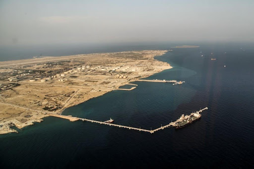
Lavan Island is situated about 18 km south of Bandar Mogham in the Persian Gulf. It serves as the operational base for three offshore fields: Salman, Resalat, and Reshadat. The island features infrastructure such as process plants, storage and export systems, utility and maintenance facilities, a storehouse, and a loading jetty.
The island terminal includes piers for handling petroleum products and LPG, as well as an SBM for managing crude exports. This port is managed by the Iranian Offshore Oil Company (IOOC), a subsidiary of the National Iranian Oil Company (NIOC). It serves as a deep-water tanker terminal capable of accommodating two ships.
Location: Approximately 10 nautical miles off the southern coast of Iran, and 170 nautical miles west of the Straits of Hormuz. The terminal is situated at the southeast corner of the island.
Port Limit: The oil loading jetty limits, controlled by NIOC, extend between the specified points.
26° 47.50′ N, 053° 22.00′ E
26° 46.40′ N, 053° 22.00′ E
26° 46.80′ N, 053° 19.40′ E
26° 47.50′ N, 053° 19.40′ E
Ships should approach from the south, as it is safe and clear of hazards. The designated anchorage zone is located east of the oil loading dock at 53 22’ E. Pilotage is mandatory, and the harbor pilot must be reached on VHF channel 16 approximately six hours prior to reaching Lavan Island.
Airport: Lavan Island Domestic, 2 km. Bandar Abbas Int’l, 320 km.
Medical: Emergency cases only.
The official UN/Locoed of this port is IRLVP. It is also known as LAVAN ISLAND, JAZIREH YE LAVAN.
Position: latitude / longitude: 26.78° / 53.34°
- Admiralty Chart: 3409
- Location: Approx. 7 Miles off the mainland coast of Iran
- Tides: In the range of 1 to 2.20 Meters.
- Anchorage: About 2 miles east of the oil loading dock
- Fresh Water & provisions: Not Available.
- Cargo: Lavan Blend Crude Oil
- Supplier/Operator: Iran Offshore Oil Company. (IOOC)
- Pilotage is compulsory. Pilot boards vessel at anchorage.
- Working hours: 24 hours a day.
Berths at Lavan Island Jetty
Outer Berth No. 1, with a depth alongside of 18.30 m, is designed for Million Barrel/Aframax tankers with an arrival displacement not exceeding 120,000 tons.
Inner Berth No. 2 shares the same overall length, with a maximum sailing draft of 10.30 m, intended for product tankers. Each berth is equipped with a Chiksan Loading Unit, featuring hydraulically operated loading arms.
Under favorable conditions, loading rates of up to 50,000 bbls/hr for crude oil and 600 tph for products like fuel oil are achievable.
| PORT’S NAME | LAVAN | |
| BERTHS | BERTH1 | BERTH2 |
| DWT MAX (MT) | 150000 | 45000 |
| L.O.A MIN (M) | 168 | 168 |
| L.O.A MAX (M) | N.A | 259 |
| Max Departure Draft (M) | 18.3 | 10.36 |
SBM
- Position: Latitude 026 45.5’ N / Long 053 20.8’ E
- Maximum Allowable DWT: 300,000 Tons
- Water depth at SBM is about 40 Meters.
- Berthing operations are carried out during daylight only.
- No oily discharge from any source is allowed, and clean ballast & pipelines must be ensured.
- Necessary arrangements should be made to accommodate on board at least seven (7) terminal staff while vessel is secured to SBM.
No restrictions in terms of arrival displacement, height of manifold, LOA, and draft.
Vessels calling Lavan SBM must be equipped with the following:
- Operational Inert Gas System.
- Operational ODME (Oil Discharge Monitoring Equipment)
- Approved type of bow fitting for SBM mooring.
- Crane or derrick on each side of mid-ship with minimum SWL of 10 Tons for handling cargo hoses.
- Accommodation ladders should be in good condition on both sides.
- 2 x 16-inch cargo manifolds on each side (Port and Starboard)
- Two smith brackets on forecastle head one on each side (port and starboard).
EDP at Lavan Island
Early Departure procedure (EDP) is available at both the jetty and Lavan SBM. Vessels not sailing on EDP basis must wait for 2-3 hours after completion of loading to collect cargo documents.