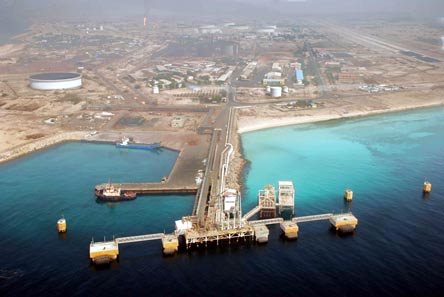
Sirri island (also known as Siri Island) is situated 76 kilometers (47 mi) from Bandar-e Lengeh and 50 kilometers (31 mi) west of Abu Musa island. The island is almost 5.6 kilometers (3.5 mi) long with a width of about 3 kilometers (1.9 mi). It covers an area of 17.33 square kilometers (6.7 square miles). The highest point on the island is 33 meters (108 feet) above sea level. Like the other islands in the Persian Gulf, it enjoys a warm and humid climate.
There is a deep anchorage close NE of the terminal. Load line zone: Tropical.
PORT RESTRICTIONS
Max draft: 23.7
Max LOA: 365
Max DWT: 350,000
Anchoring at South/East of Sirri terminal is prohibited.
Fresh Water & provision: Not Available
- Admiralty Chart: 3409
- UN LOCODE: IRSXI
- Position: 25.9166° / 54.5333° LATITUDE / LONGITUDE
- Anchorage Position: Latitude 25 57’ N / Long 54 32’ E
- Pilot position: Latitude 25 52’ 20” N / Long 54 34’ 40” E
- Water depth adjacent to loading dock at low water is 28 meters and the Keel Clearance is 1 Meter.
- Max sailing draft: 26.84 Meters
- Sirri terminal is normally the first load port
- Anchoring at South/East of Sirri terminal is prohibited.
- Vessels can anchor North East ward of loading port not less than 2 miles away from the terminal.
- Clean ballast must be be-ballasted.
- Trim must be not more than 10 feet by stern.
- Max rate of loading: 60,000 BBLS/Hour (with 2 pumps – 2 X 30,000 BBLS/Hour)
- Height of manifolds: Max 27 Meters
- Connections: Presently 2 x 16” arms with hydraulic couplers for 16”
- Medical Facilities: Available in emergency cases.
- Cargo: Crude Oil
- Supplier/Operator: Iran Offshore Oil Company. (IOOC)
- Pilotage is compulsory. Pilot boards vessel at anchorage.
- Working hours: 24 hours a day.
- Side alongside: Normally portside alongside